Nepal Floods: How a Himalayan Glacier Collapse Became a Cross-Border Catastrophe
At least 359 people have been killed and more than 1,000 remain missing after a sudden collapse of ice and rock high near the Nepal-Tibet border sent a destructive surge through the Bhote Koshi and Trishuli river systems, devastating settlements and leaving rescue teams searching hundreds of kilometres downstream.

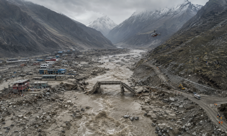
The Nepal floods began in a place where almost no one lived, high in the Himalayas near the border with Tibet. What happened there on Wednesday morning lasted only moments: a huge section of glacier ice and rock broke away from the mountainside and plunged towards the Lhende River valley below. Yet the consequences travelled far beyond the collapse site, turning a remote geological event into one of the deadliest disasters to strike Nepal in recent years.
The falling mass carried rock, snow and sediment with it before reaching the river system, where it produced an extraordinary surge of water and debris that moved towards the Nepal-China border and then south through Nepal. Settlements around Gyirong, Rasuwagadhi and Syabrubesi were among the first to be struck, but the flood did not stop there. It continued through the Bhote Koshi and Trishuli rivers towards heavily populated areas downstream, tearing apart roads, bridges, buildings and hydropower infrastructure along its route.
By Thursday, the scale of the disaster had become much clearer. At least 359 people had been killed across Nepal and China and more than 1,000 were still missing, including hundreds of foreign travellers, according to the latest international reporting on the rescue operation. In Tibet’s Gyirong County alone, Chinese authorities said 558 people remained missing, including 260 foreign nationals, while teams on both sides of the border continued searching damaged settlements and riverbanks.
Those figures may still change as communications are restored and missing-person lists are reconciled. What is already clear, however, is that the Nepal floods cannot be understood as an ordinary monsoon emergency. Scientists investigating the disaster increasingly believe that the flood developed from a sudden high-altitude ice-and-rock collapse — an event so powerful that it initially registered as what appeared to be an earthquake.
Where the Nepal floods began
The first major signs of trouble appeared shortly after 9 a.m. local time on August 26, when water levels in the upper Bhote Koshi basin began rising rapidly. The International Centre for Integrated Mountain Development, or ICIMOD, reported that a powerful surge of water, sediment and boulders had entered Nepal’s Rasuwa district from the direction of the Tibetan border and was moving through the interconnected Bhote Koshi and Trishuli systems. ICIMOD’s official assessment of the Rasuwa flood
The geography of northern Nepal magnified what happened next. Himalayan river valleys in this region are narrow and steep, with settlements, roads, bridges and hydropower infrastructure occupying the small amount of usable land between mountain slopes and rivers. When a large debris-filled flood enters such a valley, there is little space for the water to spread out and lose momentum. Instead, the terrain can concentrate its force and direct it towards the very infrastructure on which mountain communities depend.
Rasuwagadhi, an important border crossing between Nepal and Tibet, lay directly in that path. So did Syabrubesi farther downstream. As the flood moved south, it was no longer simply carrying water. It was gathering mud, boulders, trees and fragments of destroyed infrastructure, creating a dense moving mass capable of tearing structures from their foundations.
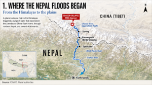
Glacier-collapse area → Lhende River → Gyirong → Rasuwagadhi → Syabrubesi → Bhote Koshi → Trishuli River.
A glacier collapse, not an ordinary rain-driven flood
The cause was initially unclear because monitoring systems detected seismic activity around the time of the disaster. Early reports therefore raised the possibility that an earthquake had triggered a landslide or flood. Subsequent analysis pointed in another direction.
Satellite imagery examined after the event showed that the lower part of a glacier had broken away, with scientists estimating that the collapsing ice and rock fell approximately 1,200 metres into the valley. The United States Geological Survey later indicated that the seismic signal had been generated by the enormous movement of glacier ice and debris itself rather than by a conventional earthquake that preceded the disaster.
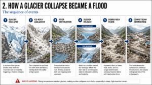
As the glacier mass descended, it collected additional rock, snow and sediment. Scientists believe that when this material reached the river valley, it may have temporarily disrupted or blocked the flow of water. The resulting release then sent a high-energy mixture of water, mud, ice and boulders racing downstream.
This distinction is central to understanding the Nepal floods. The disaster was not a case of a river slowly overflowing after prolonged rainfall. A sudden change high in the mountains appears to have transformed a river system within minutes.
ICIMOD’s preliminary assessment points to an ice-and-rock avalanche entering the Lhende Khola system upstream from Nepal, although scientists continue to investigate the exact sequence of events.
The chain of destruction can be understood relatively simply:
Glacier collapse → ice-rock avalanche → river disruption → sudden release → debris-rich flood → downstream destruction.
The river rose by metres within half an hour
Perhaps the most frightening measure of the disaster is not simply how far the flood travelled, but how quickly conditions changed. ICIMOD said the Trishuli River at Galchhi rose by as much as nine metres within 30 minutes, while at Malekhu the river rose by approximately seven metres during the same period.
Chinese government geologist Guo Zhaocheng separately estimated that the debris flow may have reached speeds of around 50 metres per second during part of its journey and extended for more than 20 kilometres. At such speeds, the time available for communities to recognise what is happening, receive a warning and move to higher ground becomes extraordinarily short.
That helps explain why the disaster caught so many people in places that might ordinarily have seemed safe. A river can appear normal while the event that will transform it is already unfolding many kilometres upstream. In this case, the initial trigger occurred in remote terrain across an international border, making the warning problem even more complicated.
One survivor, 24-year-old labourer Bibek Kumal, described hearing an unusual hissing sound before the flood reached him. He was swept away and eventually survived after becoming caught in a mango tree. His experience, reported during the first day of rescue operations, illustrates how quickly the water arrived and how little opportunity some people had to understand the danger before they were caught in it. 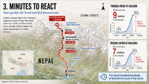
The flood grew more destructive as it travelled
Mountain debris flows behave differently from ordinary flooding. Water moving through a steep valley can collect loose soil, boulders, vegetation and material stripped from riverbanks. Every destroyed structure can contribute still more debris to the flow, allowing the moving mass to become heavier and more destructive downstream.
That process appears to have been an important part of the Nepal floods. Images from affected areas showed thick brown flows carrying large objects through settlements, while entire sections of roads and riverbanks were stripped away. Rather than simply inundating buildings, the flood had enough physical force to demolish them.
This helps explain why damage continued so far from the suspected collapse site. The initial event may have occurred high in a remote mountain valley, but the river effectively carried the disaster south with it. The flood moved through the Bhote Koshi into the Trishuli system, leaving rescue workers with a search area stretching across several districts rather than a single identifiable epicentre.
In some locations, the scale of erosion and debris deposition has changed the shape of the river corridor itself. Reconstruction will therefore involve more than replacing damaged buildings. Engineers will first have to establish where roads and bridges can safely be rebuilt in a landscape that is no longer exactly the one that existed before Wednesday morning.
Bodies were recovered far from where the flood began
The geographical pattern of casualties offers one of the clearest indications of how far the disaster travelled. Bodies were recovered not only in Rasuwa near the northern border but progressively farther downstream through Nuwakot, Dhading, Gorkha, Tanahun, Chitwan and the Nawalparasi districts.
That distribution has transformed the rescue operation. Teams are not searching one destroyed community; they are searching an entire river system. Victims and debris can be transported tens or even hundreds of kilometres from the point where they entered the water, and damaged roads make many sections of that river difficult to reach from land.
The recovery of large numbers of bodies in districts considerably south of the initial impact zone also explains why casualty figures have risen so sharply. Nepalese authorities continued updating the toll throughout Thursday as rescue teams reached new locations and additional victims were recovered downstream.
The latest consolidated reporting put the death toll across Nepal and China at at least 359, although the final figure could still rise substantially because more than 1,000 people remain unaccounted for.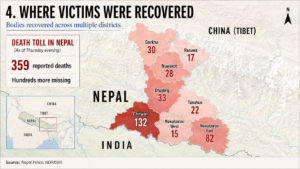
Why hundreds of foreign travellers were caught in the disaster
The remote Himalayan setting might suggest that relatively few visitors would have been in the area. In reality, the Nepal-Tibet border corridor sits on an important international travel route used by trekkers, tour groups and pilgrims travelling towards Mount Kailash and Lake Mansarovar, sacred destinations for Hindus, Buddhists, Jains and followers of the Bon tradition.
That placed hundreds of international visitors directly inside the disaster zone when the Nepal floods struck. More than 650 foreigners remained unaccounted for in the latest reporting from Nepal and China, while the missing included travellers from India, Australia and numerous other countries.
Australia said information about 34 of its citizens remained very limited, including members of pilgrimage and tour groups travelling towards Kailash and Manasarovar. Fifteen were part of a religious tour and included an 11-year-old boy. India has also been heavily affected because Indian pilgrims make up a significant portion of travellers using the route.
Establishing the true number of missing foreign nationals is proving difficult. Travellers may appear separately on lists maintained by tour operators, hotels, border authorities, embassies and families. A person listed as uncontactable may eventually be found alive in an isolated area without telephone access, while others may have crossed the border before communications were lost.
For governments and families abroad, this has turned the Nepal floods into a multinational missing-person operation as well as a natural disaster.
Roads, bridges and power infrastructure were swept away
The destruction of infrastructure has made the search itself more difficult. Roads connecting remote districts have been damaged or completely erased, bridges have disappeared and parts of the communications network were knocked out. Some hydrological monitoring equipment in the upper river basin was also lost, reducing the amount of real-time information available precisely when officials needed it most.
Hydropower infrastructure has been hit particularly hard. Nepal relies heavily on hydroelectric generation, and damage to plants in the affected corridor could produce economic and electricity-supply consequences extending beyond the immediate disaster zone.
Helicopters have therefore become essential to rescue operations, carrying injured survivors from isolated communities while delivering tents, food and emergency supplies to places that can no longer be reached by road. On the Tibetan side, China has deployed additional emergency personnel and rescue resources as authorities search for hundreds of people still missing around Gyirong.
The damage also creates a difficult reconstruction question. Rebuilding a bridge in exactly the place where it stood before may not always be possible if the river channel has moved, banks have collapsed or surrounding slopes have become unstable. In some areas, authorities may eventually have to redesign infrastructure rather than simply replace it.
Could communities have been warned sooner?
The warning timeline is likely to become one of the most closely examined questions once the immediate rescue phase is over. Conventional flood forecasting often begins with rainfall: forecasters watch storms, river gauges detect rising water and downstream communities receive alerts as the flood develops.
Wednesday’s disaster presented a very different problem. Its suspected trigger was a sudden high-altitude collapse in sparsely monitored terrain, and the event originated upstream of Nepal’s border. By the time the flood entered populated areas, the chain reaction that produced it was already under way.
The recorded rise of nine metres in 30 minutes at Galchhi illustrates how narrow the warning window can become. Satellite observation may help detect changes in glaciers and unstable mountain slopes over time, while seismic monitoring can identify major collapses. But turning those observations into useful warnings requires systems capable of recognising the threat almost immediately and communicating it downstream.
There is also an unavoidable cross-border dimension. The rivers connecting Tibet and Nepal do not recognise national boundaries, meaning upstream information gathered in China can become vital to communities farther south in Nepal.
That makes regional cooperation more than a diplomatic aspiration. It is potentially a life-saving part of disaster management. The broader issue of climate adaptation and disaster resilience has also been moving higher on regional policy agendas, including at the recent BRICS Environment Ministers Meeting in New Delhi covered by The Times of Russia. The Times of Russia: BRICS Environment Ministers Meeting 2026
A Second Flood Threat Emerges Upstream
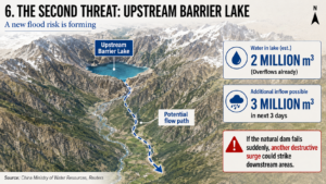
Even as teams search for survivors, the upper valley has not been declared entirely safe. Chinese authorities are monitoring a barrier lake that formed when debris obstructed water upstream near Gyirong.
The lake contained an estimated 2 million cubic metres of water by Thursday morning and was already overflowing, while officials projected that roughly another 3 million cubic metres could flow into it over the following three days.
A sudden failure of the debris barrier could send another surge downstream through areas whose roads, bridges and monitoring systems have already been badly damaged. The danger complicates rescue operations because some of the places teams must search are themselves potentially exposed to a second event.
Authorities have therefore continued evacuating people from vulnerable locations while increasing monitoring of upstream conditions. What began as a rescue operation has simultaneously become an effort to prevent one disaster from being followed by another.
The same Himalayan corridor was hit in 2025
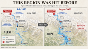
The location of Wednesday’s catastrophe is particularly significant because the region had already experienced a destructive glacial flood in July 2025. That earlier event crossed from Tibet into Nepal through the same broad Bhotekoshi corridor and damaged infrastructure around Rasuwagadhi.
Scientists linked the 2025 disaster to the sudden drainage of a glacial lake. The mechanism behind the 2026 flood appears different: evidence currently points towards a direct collapse of glacier ice and rock into the river valley.
That difference expands the challenge facing disaster planners. A dangerous glacial lake can sometimes be identified, mapped and monitored for changes over time. An unstable mixture of rock, glacier ice and degrading mountain material may be far harder to predict, particularly in remote terrain where direct observation is limited.
The broader Himalayan cryosphere is changing rapidly. A new ICIMOD assessment found that glacier area across the Hindu Kush Himalaya declined by roughly 12 percent between 1990 and 2020, alongside a significant reduction in ice reserves. The organisation has also warned that changing glacier, snow and permafrost conditions are increasing the complexity of hazards including avalanches, debris flows, landslides and glacial lake outburst floods.
What climate change can and cannot tell us
It would be premature to say that climate change directly caused this particular glacier collapse. Scientists still need to determine what destabilised the ice and rock and whether temperature, precipitation, geology or several interacting factors contributed to the failure.
That scientific caution matters, particularly in the first days after a disaster when incomplete evidence can easily harden into an inaccurate explanation.
The wider environmental context, however, is difficult to ignore. The Hindu Kush Himalaya is warming, glaciers are losing mass, snow patterns are shifting and permafrost is degrading. Those changes can affect the stability of mountain slopes and the behaviour of rivers fed by snow and ice. ICIMOD describes the region’s cryosphere as undergoing rapid transformation, with implications for hundreds of millions of people in the mountains and more than two billion people living downstream.
The Nepal floods therefore present two separate questions that should not be confused. Scientists must determine exactly why this glacier and mountainside failed on August 26. Governments must simultaneously confront the broader reality that high-altitude hazards across the Himalayas are becoming increasingly important to monitor.
A disaster shared by Nepal and China
The catastrophe has made the interconnected nature of the Himalayan border unusually visible. Nepal suffered the overwhelming share of the confirmed deaths, but hundreds remain missing in Tibet, including foreign visitors. The same collapse affected communities, travellers and infrastructure on both sides of the frontier.
China has increased monitoring of the unstable upstream region and deployed additional rescue teams, while Nepal has concentrated its efforts along the damaged river corridor. International assistance has also begun arriving as the scale of the disaster becomes clearer.
The longer-term response may require closer Nepal-China coordination in glacier monitoring, seismic detection, satellite surveillance and river-warning systems. A warning generated upstream could determine whether people downstream receive five minutes, 20 minutes or no warning at all.
Events such as this also make the wider discussion around regional climate resilience less abstract. The Times of Russia has previously reported on the growing place of resilience and sustainability within regional cooperation, including India’s 2026 BRICS agenda. The Times of Russia: India’s BRICS Chairmanship 2026 priorities In the Himalayas, that language now has an immediate human meaning: information shared across a border may ultimately determine whether a community has time to move.
Beyond the Death Toll, Hundreds of Families Are Still Searching
For the families of the missing, the scientific explanation of what happened is necessarily secondary. Across Nepal and abroad, relatives are still trying to determine whether people caught in the region were evacuated, stranded without communications or swept into the river system.
The search will become harder with time. Victims may have been transported far downstream, while thick sediment and altered river channels complicate recovery work. Roads that once connected neighbouring settlements have disappeared, and many communities remain dependent on helicopters and emergency supplies.
Eventually, engineers will rebuild bridges, reopen roads and restore power infrastructure. Scientists will reconstruct the glacier collapse from satellite imagery and seismic records. Governments will review whether better monitoring or cross-border warnings could have changed the outcome.
But the central fact of the Nepal floods is already painfully clear. A collapse in an isolated part of the Himalayas became a human catastrophe far beyond the mountain where it began, moving through an international border and down a river system faster than many communities could respond.
The lesson is not simply that Himalayan floods can be destructive. It is that the next major disaster may begin before anyone downstream can see it in a changing landscape of ice, rock and water where the distance between a remote mountain collapse and a populated valley can be measured not only in kilometres, but in minutes.